

Dec
Table of Contents
Introduction to Doi Angkhang

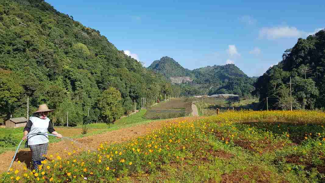
Dacoits at Doi Ma Ang Khang
It is very difficult to find information about the history of Doi Angkhang. The oldest reference I found about Doi Angkhang comes from a report by the British Consul-General in Chiang Mai, Mr. H. Fitzmaurice, dated February 7, 1931. This is what he wrote in his report:
“Among matters which I have had to hold up for the return to office of either the Lord Lieutenant or the Governor is a request from the commissioner of the Shan States to bring to the attention of the local authorities the presence of a gang of dacoits at Doi Ma Ang Khang, near Muang Fang. The Borneo Company, too, are uneasy as to the activities of this gang, as they are working forests in the near vicinity of Doi Ma Ang Khang. It would be useless to discuss this with subordinates, for it is a difficult matter for the Siamese to deal with.”

The “presence of bad characters”
Fitzmaurice continued: “The presence of bad characters at Doi Ma Ang Khang has frequently been the subject of correspondence in the past, and, as Wood stated in his letter to Mr. Wingfield of October 2nd 1929, Phya Anubal practically admitted then that the authorities scarcely minded murders or other disorders in that wild region. Doi Ma Ang Khang is, incidentally, one of the most notorious opium-growing regions in North-Siam, and any habitués who have money, if not dacoits, are probably dealers in illicit opium. I am not very hopeful of getting the Siamese here to do much, but it seems desirable to have a talk with the Lord Lieutenant or Phya Anubal before I write officially to you on the subject or reply to the Commissioner of the Federated Shan States.”

A wild and rugged border area
From the above report, it is clear that the area of Doi Angkhang was a wild and rugged area that was notorious for opium cultivation and banditry. By the way, “Wood” is W.A.R.Wood (1878-1970), who was the predecessor of Fitzmaurice as Consul-General at Chiang Mai. I have not been able to find out who Wingfield was. The Borneo Company had extensive teak forest concessions north of the town of Chiang Dao and south of the town of Fang.
Apart from this, I have not been able to find more information about this area. In 1961, 30 years later, the troops of the 3rd Kuomintang (KMT) army crossed the border here and established settlements in this area. One of these settlements was Tham Ngob, which became the headquarters of the 3rd army under the command of General Li Wen Huan. The abandoned buildings are still there. They are a fortified main house, barracks, and other auxiliary buildings. Several years ago there was a small restaurant with old pictures on the wall, run by the daughter of General Li. On my last visit in February 2025, there was no one at this place.

Communities on Doi Angkhang
According to my information, there are nine communities in Doi Angkhang. Five of these are ethnic Yunnanese (Chinese) villages: Ban Khum, Ban Luang, Ban Tham Ngob, Ban Sin Chai, and Ban Pha Daeng. The inhabitants are either descendants of the Kuomintang (KMT) troops who entered the area in 1961 or they are related to the Chin Haw traders, whose caravans transported goods in the region, including opium. On the road from Chiang Dao to Doi Angkhang you will pass the sprawling Yunnanese (Chinese) community of Arunothai.


Indigenous communities on Doi Angkhang
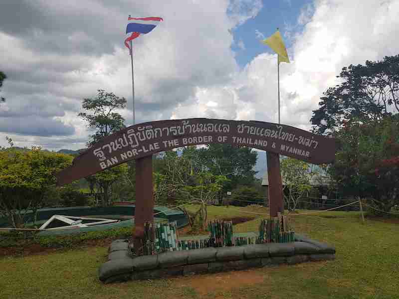
There are two indigenous communities on the mountain. Probably the oldest village is Ban Kob Dong, a Black Lahu community that might have moved into the area in the 1960s or even earlier. Pictures in the villages show a youthful King Bhumibol Adulyadej visiting the village and talking to local people. The other village is Nor Lae or Noh Lae, a Dara-Ang (Palong) village, which is located right on the Thai-Myanmar border. These villagers crossed the border from Myanmar in the 1980s. Although many Palong people settled in Chiang Dao district, some people stayed right on the border. Both villages are worth a visit.

The Angkhang Royal Agricultural Station
As we have seen from the report of consul Fitzmaurice the Doi Angkhang mountain range was already notorious for banditry, opium cultivation, and drug trade in the 1930s. I found different dates but most likely the establishment of the Angkhang Royal Agricultural Station started in 1979. After that the station grew into the largest Royal Project in the country, covering about 318 ha. You need a vehicle to visit this extensive station that experiments with growing many cash crops and flowers as substitutes for opium.
Peach, persimmon, Japanese apricot, kiwi, avocado, strawberry, Arabica coffee, Chinese tea, organic vegetable, roses, Calla Lilly flowers, potted plants, and Portobello mushrooms are some of these crops and flowers. The closure of the accommodation in Ban Khum in 2019 resulted in a significant drop in visitors to the project. Allegedly, this caused the project to release hundreds of its workforce, a very sad development.

Doi Angkhang as a tourist destination
Authorities developed the Royal Agricultural Station as a tourist destination with a restaurant and accommodation in the 1980s. In the 1995 edition of the guidebook Thailand: a Travel Survival Kit, writer Joe Cummings mentioned Doi Angkhang very briefly as the “Little Switzerland” of Thailand.
Around the year 2000, the Angkhang Nature Resort was constructed. The Amari Hotel group took on the management of the hotel, which became known as the Amari Angkhang Nature Resort. This was the only upscale hotel on the mountain. It was an Amari Resort at least until 2015. Sometime after that, the owners of the hotel ended their relation with the Amari Group, after which the hotel was called The Angkhang Nature Resort.
The Bangkok Post broke the news on April 4, 2019, that the resort was handed over to the Royal Agricultural Station Angkhang (RASA). To rehabilitate the ecosystem, RASA intended to demolish the resort with help of the military. When I visited in July of that year the resort had vanished from the face of the earth.

Where to stay now
The main community on the mountain is the Chinese village Ban Khum, where also the entrance is of the Royal Agricultural Station. There are a couple of small restaurants here. Ban Khum was also the location of several guesthouses and the only hotel, the Angkhang Nature Resort. As far as I know, all these accommodations had to close after Doi Angkhang became part of the Doi Pahom Pok National Park in 2019.
Consequently, they demolished the Angkhang Nature Resort. Nothing is left of this accommodation apart from the driveway and the pathways between the bungalows. If you want to spend the night the only option is organized camping at two places. In October 2019 I stayed at the main camping site which is a couple of km from Ban Khum. You can rent a tent for the night at a beautiful viewpoint next to a huge parking lot. The tent is already set up so you don’t have to do it yourself.
There is a park headquarters building and a coffee shop. The tents are very close to a large view deck from where you can observe the “sea of clouds” at around sunrise. The other camping site is opposite the Sui Thang viewpoint where also a ticket booth is. I have never seen this booth active.

Doi Pha Hom Pok National Park
As mentioned Doi Angkhang has become part of the Doi Pha Hom Pok National Park in 2019. Since then Doi Angkhang has, like all national parks in Thailand, an entrance fee. There is a ticket booth opposite the Sui Thang viewpoint but the entrance seems to be only for people who spend the night in the park. As far as I could see the other entry point of the park is at the other camping site near Ban Khum. I made the below picture of the entrance fees and overnight prices at the office there.
You can therefore still visit Doi Angkhang on a drive-through basis and visit the Royal Project as well as the two interesting hill tribe villages.


How to get there
There is no public transportation available to Doi Angkhang so you will need a private vehicle to take you there. There are two ways to get to the mountain: if you come from Chiang Mai you should drive to Chiang Dao, take road 1178 to the Wiang Haeng intersection, and continue to the Ban Arunothai and the Myanmar border along road 1340. Continue to Doi Angkhang via the Chinese villages Sinchai, Tham Ngob, and Pa Daeng. I really enjoy driving this road.
Another way is to take road 1249 from Fang district. This is a shorter but very steep route with hairpins. This road can be tricky, especially when it rains. Views are fantastic. I prefer to drive this road down instead of up. The last time I drove this road I was held up for half an hour because of an accident with a minivan. Driving to and on Doi Angkhang can be very tricky and dangerous. The roads are narrow and winding so you should have some driving experience in Thailand before you go there.

References for Doi Angkhang
Google Map of Doi Angkhang
Doi Angkhang in Green Trails programs
We feature the mountain in two of our expeditions: The Ancient Caravan Trail to Chiang Rai and The Explore North Thailand Tour. It also features in the journey From Chiang Mai to the Mekong River from our sister brand Chiang Mai a la Carte. It also appears on the page: Things to do in the Golden Triangle.

Share this:
